- What Makes Ha Giang Feel Like a Hidden World?
- A karst universe, not just mountains
- Clouds are part of the landscape
- The roads cut through “impossible” terrain
- The Best Places to See Ha Giang’s Limestone-and-Cloud Landscapes
- Dong Van Karst Plateau: the core landscape zone
- Quan Ba Heaven Gate: the first big reveal
- Ma Pi Leng Pass and the Nho Que River gorge: the headline scenery
- The quieter “hidden world” moments
- Best Time to Visit for the Limestone-and-Cloud Effect
- Best overall windows: spring and autumn
- Rainy season caution
- A practical visibility rule
- How to Experience the Landscape?
- Easy rider or small group: best for most first-timers
- Car or jeep: best for comfort and photography
- Self-ride: only if you are confident and prepared
- Plug-and-Play Scenic Itinerary Templates
- 3D2N: short but cinematic
- 4D3N: hidden-world pace
- Safety and Comfort Notes
- What to Pack for Limestone Ridges and Cloud Weather?
- FAQs
- What is the Dong Van Karst Plateau and why is it famous?
- Where is the best viewpoint in Ha Giang for dramatic scenery?
- What is Quan Ba Heaven Gate and is it worth stopping?
- What is the best season to see Ha Giang clearly?
- Conclusion
Ha Giang does not look like “normal” Vietnam. What makes it feel like a hidden world is the combination of limestone karst formations, high mountain roads, deep river gorges, and fast-changing cloud cover across Vietnam’s far north. Much of the region’s signature scenery sits within the Dong Van Karst Plateau UNESCO Global Geopark, which UNESCO recognizes for its exceptional geological value and Vietnam Tourism presents as the core of the Ha Giang Loop experience.
For most travelers, the most unforgettable landscape moments happen along the classic Loop corridor, especially around Quan Ba Heaven Gate, the Dong Van Karst Plateau, and Ma Pi Leng Pass above the Nho Que River gorge. For the best mix of visibility and comfort, current travel guidance most often favors spring (March–May) and autumn (September–November), while wetter months can still be beautiful but are more challenging for riding and viewpoint reliability.
What Makes Ha Giang Feel Like a Hidden World?
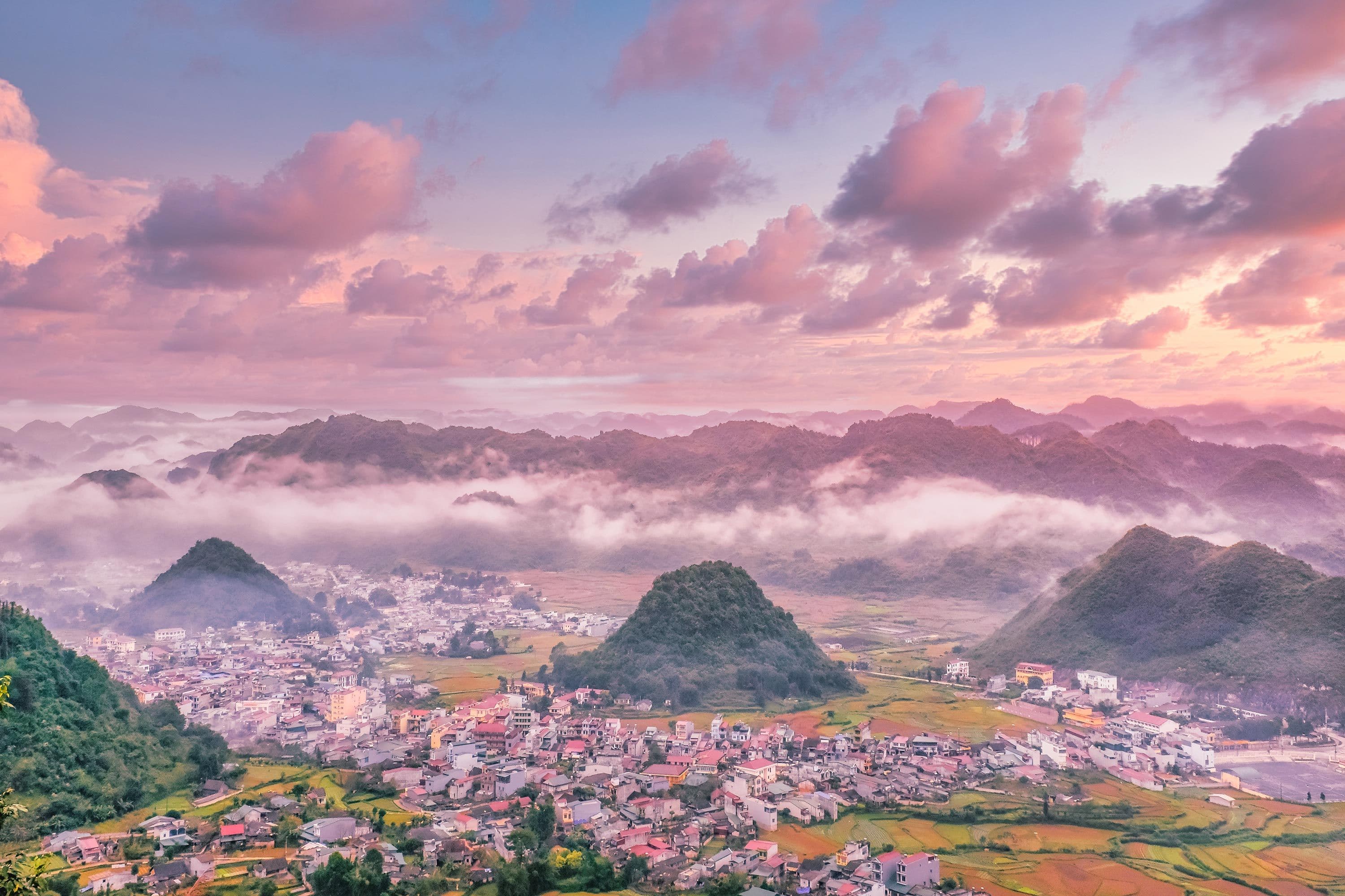
A karst universe, not just mountains
Ha Giang’s defining feature is not simply “high mountains.” It is the karst landscape of the Dong Van Plateau: jagged limestone peaks, steep valleys, cliffs, and rock formations shaped over immense geological time. UNESCO describes the Dong Van Karst Plateau as a Global Geopark in Ha Giang Province, and Vietnam Airlines’ geopark guide highlights its stone forests, sharp ridgelines, and dramatic plateau scenery.
Clouds are part of the landscape
In Ha Giang, clouds do not just sit in the background. They actively change the scene. Views can open, close, and reopen in the same morning, especially around the higher passes. This is why the same viewpoint can feel cinematic one minute and completely hidden the next. That is an inference supported by the region’s repeated seasonal guidance emphasizing clearer months and caution in wetter, lower-visibility periods.
The roads cut through “impossible” terrain
The Ha Giang Loop became famous because the roads do not merely cross the scenery; they reveal it. Vietnam Tourism describes the Loop as a route over high passes and deep abysses, while its four-day road-trip guide singles out the road from Dong Van to Ma Pi Leng as one of the most mind-blowing stretches in Vietnam.

The Best Places to See Ha Giang’s Limestone-and-Cloud Landscapes
Dong Van Karst Plateau: the core landscape zone
If you want to understand the geological identity of Ha Giang, this is the place. The Dong Van Karst Plateau is the landscape engine behind the region’s “hidden world” feeling: high stone plateaus, severe valleys, exposed limestone, and roads that seem carved into the mountains. UNESCO’s recognition is one reason the landscape feels more significant than just a scenic road trip.
Quan Ba Heaven Gate: the first big reveal
This is one of the classic opening viewpoints on the Loop and often the first place where travelers feel they have entered a different world. Quan Ba Heaven Gate is commonly framed as a gateway into the plateau, with broad views toward the valley and the Twin Mountains area. Recent travel guides and image results consistently associate it with that first major “wow” moment.
Ma Pi Leng Pass and the Nho Que River gorge: the headline scenery
This is the most iconic segment of the Ha Giang landscape. Vietnam Tourism’s four-day Loop guide describes the road from Dong Van to Ma Pi Leng as a stretch of giant peaks, canyons, and nonstop panoramic views, while Vietnam Airlines’ Nho Que River guide specifically ties the river experience to the dramatic Ma Pi Leng section above it.
If you only remember one image from Ha Giang, it is often this: a knife-edge road high above a deep river gorge, with limestone walls dropping away beneath shifting clouds.
The quieter “hidden world” moments
The best mood is not always at the busiest viewpoint platform. It often shows up in early-morning rides, slower valley stops, and short unhurried pauses between headline places. That is an inference from how tourism sources describe the Loop’s roadside scenery, refreshment stops, and panoramic pull-offs as part of the route’s appeal, not just the named landmarks.
Best Time to Visit for the Limestone-and-Cloud Effect
Best overall windows: spring and autumn
The strongest broad windows are March–May and September–November. Current Ha Giang guidance repeatedly highlights these periods for comfortable riding conditions and better scenic payoff, while Vietnam Tourism specifically notes September and October for golden fields on the Loop.
Spring gives you a cleaner balance of comfort and visibility. Autumn adds stronger harvest color and some of the most photogenic road-trip conditions.
Rainy season caution
Wetter months can be intensely lush, but they are less forgiving. Vietnam Airlines’ geopark guide specifically warns against heavy-rain periods, especially late June to early August, because mountain roads can become dangerously slippery. That does not make the landscape less beautiful, but it does make the experience harder and more weather-dependent.
A practical visibility rule
Protect early mornings for major viewpoints. Later in the day, cloud build-up, haze, fatigue, and weather changes tend to make your best scenic windows less reliable. This is an inference from the region’s variable mountain weather and the consistent emphasis on clearer-season planning rather than all-day certainty.
How to Experience the Landscape?
Easy rider or small group: best for most first-timers
For many travelers, this is the smartest way to enjoy the scenery. You stay present with the landscape instead of splitting your attention across navigation, road conditions, and fatigue. This recommendation follows naturally from Vietnam Tourism’s own description of the Loop as a demanding mountain-road journey.
Car or jeep: best for comfort and photography
A car-based route makes sense if you want more gear stability, easier weather pauses, and less physical strain. Vietnam Airlines’ north-Vietnam itinerary guide includes Ha Giang by car as a realistic way to explore the plateau and Ma Pi Leng section.
Self-ride: only if you are confident and prepared
The roads in Ha Giang deserve respect. The Loop is famous partly because it is dramatic, and that drama comes with sharp curves, exposure, and fast-changing conditions. Self-riding is best reserved for travelers who are both skilled and properly prepared.
Plug-and-Play Scenic Itinerary Templates
3D2N: short but cinematic
Day 1: Ha Giang City → Quan Ba Heaven Gate zone → Yen Minh
Day 2: Yen Minh → Dong Van → Ma Pi Leng Pass → Meo Vac
Day 3: Return with slower scenic stops
This works because it captures the most iconic arc of the landscape without trying to turn every hour into a stop. Vietnam Tourism’s official four-day route uses a very similar structure, just with more breathing room.
4D3N: hidden-world pace
If you want Ha Giang to feel more meaningful, add a day. The official four-day route better protects photo stops, market moments, and the shift from gateway valleys to high karst drama. Less rushing usually means the landscape feels more distinct and memorable.
Safety and Comfort Notes
Weather shifts are normal in Ha Giang. Wind, mist, cloud, and sudden rain can change both road safety and viewpoint quality quickly, which is why buffer time matters so much. Vietnam Airlines’ geopark guide explicitly warns that heavy rain can make mountain roads dangerous.
Another practical truth: viewpoints are better when you are not exhausted. The Loop’s roads are physically and mentally tiring, so fewer high-quality stops almost always create a better day than constant stop-hopping. That is an inference supported by the route’s long, curving mountain-road structure in Vietnam Tourism’s official itinerary.
What to Pack for Limestone Ridges and Cloud Weather?
Bring:
-
layers for warm-to-cool swings
-
a light rain shell
-
shoes with grip
-
a waterproof phone pouch
-
a power bank
-
sunglasses and sunscreen for clear high-altitude days
These are practical essentials because Ha Giang mixes altitude, exposed viewpoints, and rapidly shifting weather. The need for extra caution in wetter periods especially supports grip and rain protection.
FAQs
What is the Dong Van Karst Plateau and why is it famous?
It is a high limestone plateau in Ha Giang Province recognized by UNESCO as a Global Geopark, famous for its dramatic karst terrain, deep valleys, and geological significance.
Where is the best viewpoint in Ha Giang for dramatic scenery?
For most travelers, Ma Pi Leng Pass is the headline answer because it combines cliff-edge road views with the Nho Que River gorge far below.
What is Quan Ba Heaven Gate and is it worth stopping?
Yes. It is one of the Loop’s classic early viewpoints and is often treated as the gateway into the karst plateau, with sweeping views toward the valley and Twin Mountains area.
What is the best season to see Ha Giang clearly?
The safest broad answer is spring (March–May) or autumn (September–November) for the best balance of visibility, comfort, and road conditions.
Conclusion
Ha Giang feels like a hidden world because the landscape is genuinely different. It is not just mountainous; it is a UNESCO-recognized karst plateau of limestone peaks, deep gorges, cloud-wrapped ridges, and roads cut into improbable terrain.
Go in spring or autumn for the best balance of comfort and visibility, build your route around Quan Ba Heaven Gate and Ma Pi Leng Pass, and give the landscape enough time to reveal itself. Done that way, Ha Giang delivers one of those rare travel feelings: not just that you saw somewhere beautiful, but that you briefly entered a place that feels almost separate from the rest of the world.


Founder & Photography Guide
Specialties: Culture, landscape, portrait, hiking, active and adventurous tour
Besides my unlimited passion for traveling, a professional tour guide for over a decade, I have been taking photographs since sitting at Hanoi of the University of Culture in the early 2000s. Photography started as a hobby but it was seriously taken due to my work relations and my significant passion for the beauty of our world, especially in Southeast Asian parts such as Vietnam, Laos, Cambodia, and Myanmar.
Within a few years of taking photographs, my works began to be recognized by many reliable international publications such as AFAR Travel, The Times, and The Daily Telegraph newspaper. In addition, I continuously add to my growing profile by winning numerous major awards: 3rd Position of The Independent Photographer 2018, 1st Position of Amateur Photographer of the year 2018, Grand Prize Winner of the AFAR Travel Photography 2019, and a Gold Award of San Francisco Bay International Photography 2020.
I photograph a wide variety of subjects, from travel to landscapes to street scenes. I enjoy documenting the East’s rich cultural heritage and its land soaked in glorious sunrise or sunset light in remote and secluded spots. And, I am very happy to share my knowledge and experience with you. You can visit Luminousvietnamtour to explore tour!